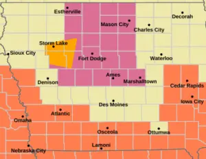
The National Weather Service has issued a severe thunderstorm watch until 5 p.m. Friday for 23 northern Iowa counties, including Cerro Gordo, Franklin, Hardin, and Wright in the broadcast area.
Forecasters say scattered storms are possible throughout the afternoon and evening, with damaging winds being the primary threat. Residents are advised to stay alert and monitor local weather updates.
The Hazardous Weather Outlook from the Des Moines office notes a marginal risk for severe weather across northern Iowa today. Spotters may be needed to report conditions, and intermittent storms are expected to continue through the weekend, particularly along the Iowa-Minnesota border.
The weekend is expected to be hot, with heat indices potentially exceeding 100 degrees. Local weather information is available in the RadioOnTheGo mobile app and online at radioonthego.com/forecast.