Warmer temperatures and rainfall deficits in October have led to deteriorating drought conditions across the state, according to the latest Water Summary Update.
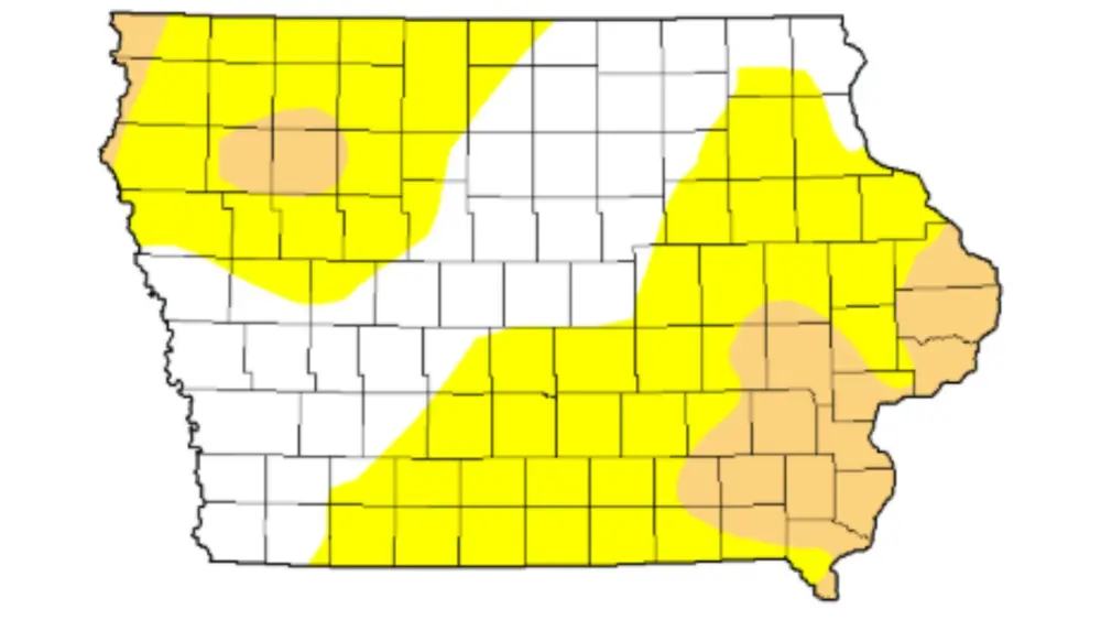
Reduced rainfall since late summer finally took a toll as drought returned to the state in early October and expanded in southeastern and northwestern Iowa. Much of the state is experiencing abnormally dry or moderate drought conditions.
At the end of October, Iowa’s statewide precipitation totaled 2.06 inches, or 0.62 inches below normal. Some reporting stations in northwest and southeast Iowa showed deficits of one to two inches or more for the month. Statewide temperatures averaged 57.2 degrees for the month, 6.2 degrees above normal, ranking it near the top 15th warmest October in the 153-year record.
The U.S. Drought Monitor (USDM) shows that two-thirds of Iowa is abnormally dry, with moderate drought impacting both the southeastern and northwestern regions. According to Iowa’s Drought Plan, nearly all drought regions experienced worsening conditions in October, with the sole exception in southwestern Iowa, where conditions remained mostly unchanged. In the broadcast area, abnormally dry conditions can be found in extreme southeastern Grundy County. The rest of the broadcast area is drought free.
The National Weather Service’s Climate Prediction Center’s November outlook indicates an equal chance for above, below, or near-average precipitation across the entire state and an increased likelihood of warmer-than-average temperatures. The seasonal outlook suggests continued concern for drought development in areas where deficits are already established.
For more information on Iowa’s water trends, visit iowadnr.gov/watersummaryupdate.