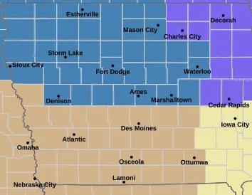

A Winter Storm Watch is now in effect for much of central and northern Iowa from this evening through Wednesday morning, and forecasters warn that blizzard conditions are possible. The National Weather Service in Des Moines says winds will intensify this (Tue) evening, with gusts reaching 50 to 60 miles per hour. With more than six inches of snow already on the ground, officials say any surface crust will break down quickly, creating significant blowing and drifting snow. Near white-out or full blizzard conditions may develop overnight.
The watch includes our entire broadcast area — Franklin, Butler, Hardin, Grundy, Wright and Cerro Gordo Counties and communities from Emmetsburg and Algona to Fort Dodge, Ames, Marshalltown, Waterloo, and many towns in between. Travel could become treacherous to nearly impossible, especially on bridges and overpasses. The commute tomorrow (Wed) may be heavily impacted, and forecasters warn that falling tree branches are also possible in the strong winds.
Residents are urged to prepare for deteriorating weather and continue monitoring updates from the National Weather Service. Links to online sources are available below.